Tsetserleg and Arkhangai
This is the 'Aimag' or regional capital in the centre of the country and is one of Mongolia's most beautiful towns. From here teams can head south west and complete both foot and horse trekking. The scenery is hugely varied from open steppes to forests to meandering rivers. There is also the opportunity to summit the highest mountain in the Arkhangai region. Alternatively teams can head north west to the Terkhiin Tsagaan Nurr, also known as the Great White Lake, situated within the Korgo Terkhiin Tsagaan Nurr National Park. The Park is characterized by high mountains, an extinct volcano and protected wildlife.
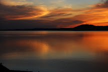
Terkhiin Tsagaan Nuur
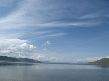
Known in English as the Great White Lake, this freshwater lake (and the volcanic area around it) is certainly the highlight of Arkhangai, and one of the best in a country full of beautiful lakes. Surrounded by ex¬tinct and craterous volcanoes (part of the Tarvagatain Nuruu range), Terkhiin Tsagaan Nuur is not as forested or as large as Khovsgol Nuur, but it is closer to Ulaan Baatar, completely undeveloped and just about perfect for camping (though there are a few flies in summer). The lake, birdlife and mountains are now protected within the 77,267 hectare Khorgo-Terkhiin Tsagaan Nuur National Park. The lake, which was formed by lava flows from a volcanic eruption many mil¬lennia ago, is excellent for swimming, though a bit cold in the morning - try the late afternoon, after the sun has warmed it. It even has what may be Mongolia's only truly sandy beach. The fishing is good, though you should get a permit for around T 2000 per day. There are several park
Lake of Ugii Nuur Ugii Nuur is a lake, 1.337 meters above sea level in Ugii Nuur soumin Arkhangai aimag. It covers 25 square kilometers, and is rich in Perch and pike. The catch possible from the lake of Ugii Nuur is 50 tons a year. Swan Goose, White Spoonbill and Dalmatian Pelican have been recorded.
Sacred pinnacle of granite Taihar Chuluu is a mysterious steep-sided pinnacle of granite, 25 meter high; almost impossible to climb-rising abruptly from the flat grassland of the gravel spreads of the Tamir river.
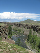
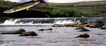
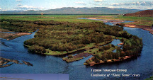
Chuluut river and its canyon The Chuluut River rises in Egiin Davaa of the Khangai Mountain Range and flows for 415 kilometers north to join the Ider River, thus forming the Selenge River. The Chuluut River flows through a sheer basalt canyon, which extends 100 kilometers from of lava of nearby extinct volcanoes such as Khorgo Volcano and others. The Chuluut river is rich in fish
Horgo Mountain and Terkhiin tsagaan Nuur Lake Horgo Mountain is a dormant volcano located on the east shore of Lake Terhiin Tsagaan (2,100 m above sea level). Horgiin Togoo is the highest volcano crater in the Orkhon River Valley. >From the summit of this basalt-covered mountain one has a splendid view over the whole region and the lake. The volcanic crater of the Togoo Uul is 200m wide and 100m deep. The northern slope is covered with Siberian Larch. One of the most interesting sights of Horgo is the so-called Basalt. Ger, which lies on the southern side. It is a large solidified bubble of lava with a broken piece on one side, which makes a natural door. The height of some of these stone gers is 1.7m. Several other ancient volcanoes are not far from the Horgo. Lake Terhiin Tsagaan was formed when volcanic lava dammed the Suman River, cutting a large gorge through the basalt. It is an astonishingly beautiful lake, 20 km long, 16 km wide and 4 to 10 meters deep with an altitude of 2,060m above sea level.
Choidogiin Borgio Choidogiin Borgio is a waterfall cascading from the Chuluut and Suman rivers confluence, over a sheer cliff with a height of 2 meters. It is interesting to watch fish in the waterfall. Several other waterfalls interrupt the flow of the Chuluut River.


Ай.. Ай даа...
-
Миний буруугаас буудал өнгөрөөд явчихсан уу? Ямар нэртэй буудал?
Юу?Хүргээд өгий гэхэд яалаа!....За нэг юм сараачаадахаас. Банжигаа санаад
баахан блог унш...
12 years ago


No comments:
Post a Comment